Beta bringing heavy rain and flooding to Texas and Louisiana
-
Update: 22nd of September, 9:00 a.m.
Storm Beta made landfall on Monday night near the Matagorda Peninsula around 10 p.m. CDT. It is forecasted to produce heavy rain across the Texas and Louisiana coasts over a long period.
The entire area is under a flash flood watches. Storm is expected to slowly weaken as it moves more inland during Tuesday, however it will stay close to the coast of southeastern Texas through Tuesday to Wednesday.
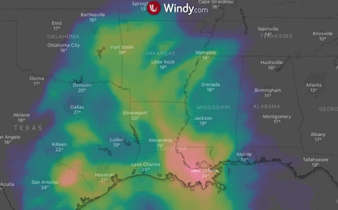
Later in the week, Beta will bring rain to Arkansas, Texas and Louisiana and Lower Mississippi Valley.
Update: 21st of September, 8:00 a.m.
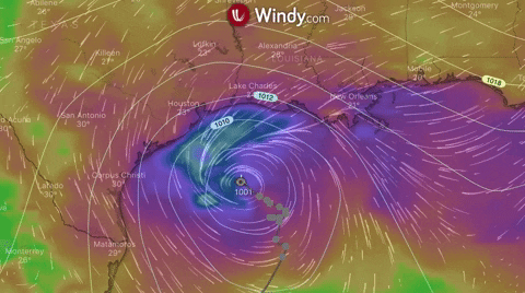
Beta is located east-southeast of Port Oconnor Texas, travelling at a slow motion along the Texas coast to southeast Louisiana, where it will produce long-lasting rainfall.
Storm surge warning has been issued for Port Aransas, Texas to Rockefeller Wildlife Refuge, Louisiana, including Copano Bay, Aransas Bay, San Antonio Bay, Matagorda Bay, Galveston Bay, Sabine Lake, and Lake Calcasieu.
Tropical-storm-force winds will affect Texas coast today through Tuesday.
Update: 20th of September, 8:00 p.m.
Storm Beta is travelling through the northwest of Gulf of Mexico with sustainable winds of 95 km/h (60 mph). Landfall is predicted on Monday or Monday night.
Beta is currently affecting coastal Louisiana and Texas with showers and thunderstorms. The threats are flooding rainfall, storm surge and gusty winds.
Due to the dry air and wind shear, Beta is not expected to become a hurricane upon its landfall anymore.
Tropical storm warnings are in effect for Port Aransas, Texas, to Morgan City, Louisiana, including Houston and Victoria, Texas, and Cameron, Louisiana.
https://www.windy.com/-Wind-accumulation-gustAccu?gustAccu,24.575,-96.888,6,i:pressure,internal